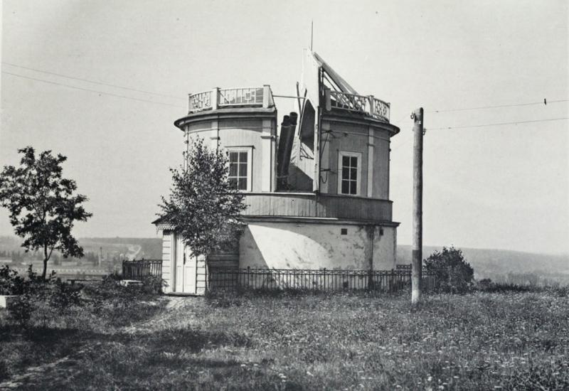
February 7, 2009 on the territory of the Observatory of Taras Shevchenko National University of Kyiv (str. Observatorna 3) was opened annotative board dedicated to Kyiv meridian. Its coordinates were defined by the first director of the Astronomical Observatory of the University of St. Vladimir prof. V.F.Fedorov in 1845. Kyiv Official length - 2 hours, 2 minutes and 1 second. If you draw a straight line to the south and north of the memorial plaque, on the south of Kyiv meridian passing through the forest Goloseevsky ave. 40 years of October Str. University (№4), lost in the depths Demiivka and Sovsky lakes, Baykove cemetery in Protasov Yar industrial zone, crossing the street. Zhilyanskaya (№69-71), street intersection between B. Khmelnitsky and Honchar streets. From the observatory north, he crosses the street. Artem (№20), after Glubochitsky (№53) goes to the Old Believers cemetery and hem industrial park, and from the metro "Petrivka" is exactly in Obolonskiy Avenue - or rather, avenue was accidently paved almost on Kyiv meridian.
Meridian is still passing through the observation pavilion 164-year-old observatory and is related to a long and interesting history. Being put by another BC ancient Greek astronomer and mathematician Hiparhom Nicea, coordinate system on the earth's surface in the form of latitude and longitude for almost two millennia faced with the problem of the origin of longitude. Coordinate lat pegged to the earth pole and astronomical observations can easily be determined by measuring the height of the so-called pole world - the point of intersection of the axis of rotation of the Earth from celestial sphere, around which daily perform mental rotation of all the heavenly bodies. But length doesn’t have any fixed targets neither in the sky, nor on earth, its starting point is arbitrary and for long time hasn’t had any agreed position among different countries and peoples.
This starting point was "wandering" around the globe. They tried to fix meridian the most remarkable natural formations. It was a steep cliff Gibraltar Bay - the so-called "Pillars of Hercules", the western edge of Africa, Cape Verde Islands, the volcano on the island of Ferro (Canary Islands) and many others. Conducted through the origin longitude known cities, palaces and castles - Alexandria, Egypt, where the famous Museyon was created; Frauenborh castle, where Nicolaus Copernicus lived and worked, Tycho Brahe’s famous Observatory Uraniborg, the Spanish city of Toledo Island and others.
The problem of determining longitude concerned sages and kings, dignitaries and secular lords. 1567 King of Spain, Philip II appointed a reward for solving the problem of determining longitude at sea, 1598 Philip III promised reward - 6 000 Ducats as a permanent contribution, 2 thousand Ducats in the form of lifetime annuity and 1 thousand Ducats to help anyone who can "open longitude." In 1620's United Province of Holland appointed a prize of 30 thousand. Florins method for accurate determination of longitude. In the XVII century. remuneration for the same promise and Portugal Venice. 1714 in England was read Bill of social promotion and financial reward of 20 thousand Pounds to anyone who could determine longitude at sea.
Almost until the end of the nineteenth century each country, and often the province or territory determined longitude on their own, but the maps sailors often could be seen simultaneously several readout scales. As longitude closely associated with the delayed start, it was the same confusion and timeline, creating constant confusion. To deal with this problem on a global scale they have tried many times, for example, in 1634, Cardinal Richelieu called the geographic council known European mathematicians and astronomers to select the initial meridian. But only a decision of Meridian Commission in 1884 was recognized as common to all Meridian passing through Greenwich Naval Observatory. Though not immediately, but over time, most countries have accepted and understood the convenience of a single readout meridian and conventional jet lag.
But today in many cities around the world marked with commemorative stele, sculpted groups medallions on the pavement, steel bands, street names and even palaces, buildings and walls on floors meridians many medieval churches that carry the names of the places where they were identified ( mainly astronomical methods) exact position on Earth - Paris meridian, Prague, Benatskyy, Rome, Pulkovo, Kyiv and many others.

